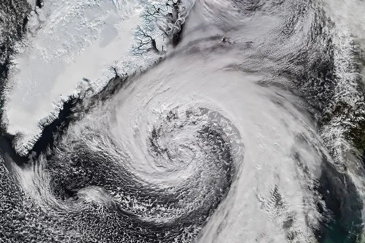
NASA Earth Observatory published a satellite account on October 21, 2026, of an extratropical cyclone passing Iceland. The NOAA-21 VIIRS image was captured on October 14, showing a large spiral of clouds across the North Atlantic. The feature connects the system with the remnants of Hurricane Isaias after their journey from the western Atlantic.
A changed system, not simply a changed name
The report describes the transition from a tropical weather system into an extratropical cyclone. The resulting structure and surrounding weather relationships differ from those of the earlier hurricane. An older storm name can help explain the history, but it should not obscure the fact that the system has evolved.
The published image is a dated observation. It does not show present conditions near Iceland and should not be presented as a current alert. Keeping the capture date alongside the image is especially important when dramatic weather photographs circulate outside the report that originally explained them.
A lesson in maintaining data context
Our analysis is that the same problem appears in many information products. A record remains visually persuasive after the circumstances it describes have changed. If a timestamp or explanatory label disappears during sharing, the audience may draw a conclusion that the original evidence does not support.
A hypothetical operational dashboard can address that problem by showing the observation time, source and update status together. It can also distinguish a historical comparison from the current state. Those details help a reader understand what the display can establish before acting on it.
The cyclone feature is useful as a record of system evolution and the contribution of satellite observation. For travel, infrastructure or safety decisions, readers need current information from the relevant authorities. Historical imagery supports understanding; it should retain its date and context as it moves between publications and screens.